When Congress approved the Federal-Aid Highway Act in 1956, it authorized what was the largest public works program in U.S. history. It was used to build 41,000 miles of highways that connected 42 capital cities, as well as ninety percent of US cities with populations greater than 50,000 (Knight 2007). It sought to enhance travel between these cities and improve commerce, but negatively impacted many urban communities of color (Mulcahy 2001). The project reportedly displaced more than one million people across the US (Renckens 2012). In Syracuse the community that was directly affected was the 15th Ward.
The 15th Ward
Syracuse, like many other cities throughout the United States, had its different ethnic neighborhoods. The Italians lived in Solvay, the Irish lived on Tipperary Hill there was a vibrant Polish community on the West Side, and the Jewish and Black residents lived in the 15th Ward.
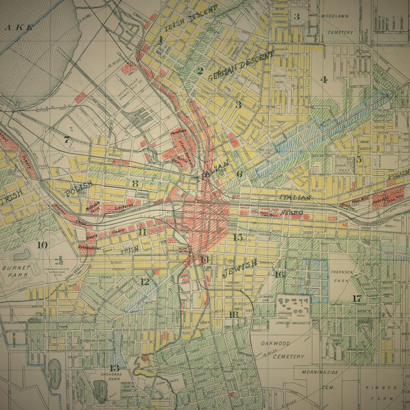
Map published by Syracuse engineer Henry C. Allen (1919)
At the turn of the 19th Century, the 15th Ward was a thriving Jewish and Black community. In the early 1900s, black families began moving north in the United States in hopes of finding work that paid better wages. Some of these families settled in the 15th Ward, where ninety percent of the black population in Syracuse lived.
Three synagogues and Jewish-owned stores and businesses supported this self-sufficient community in Syracuse. As one resident, Marvin Simner (2006 ) reported, there was a sense that it was a safe environment to allow your children to roam free knowing that they would be protected and watched over by others in the community.
The surrounding community had relegated the growing Black community within the 15th Ward (Struck 2022).Banks utilized maps provided by the Federal Housing Administration (FHA) determine the creditworthiness through redlining, which promoted segregation (Ished 2023). Realtors were told not to show any homes for sale outside of the Ward to black families or “there was the devil to pay” (Struck 2022). This forced overcrowding among black residents. Without access to bank loans, homes became run down, and property values decreased in this corridor going through the center of Syracuse (Knight 2007).
By the 1950s, a majority of the Jewish families had moved to different neighborhoods in and around Syracuse because they were given access to loans, but there were still many Jewish owned businesses that served the new Black community (Jonzella 2017).
With the Federal Highway Act and the Urban Renewal program, the city administration along with state and federal officials determined the 15th Ward would be the ideal place to build the I-81 highway to break up what they deemed was one of the slums of Syracuse.
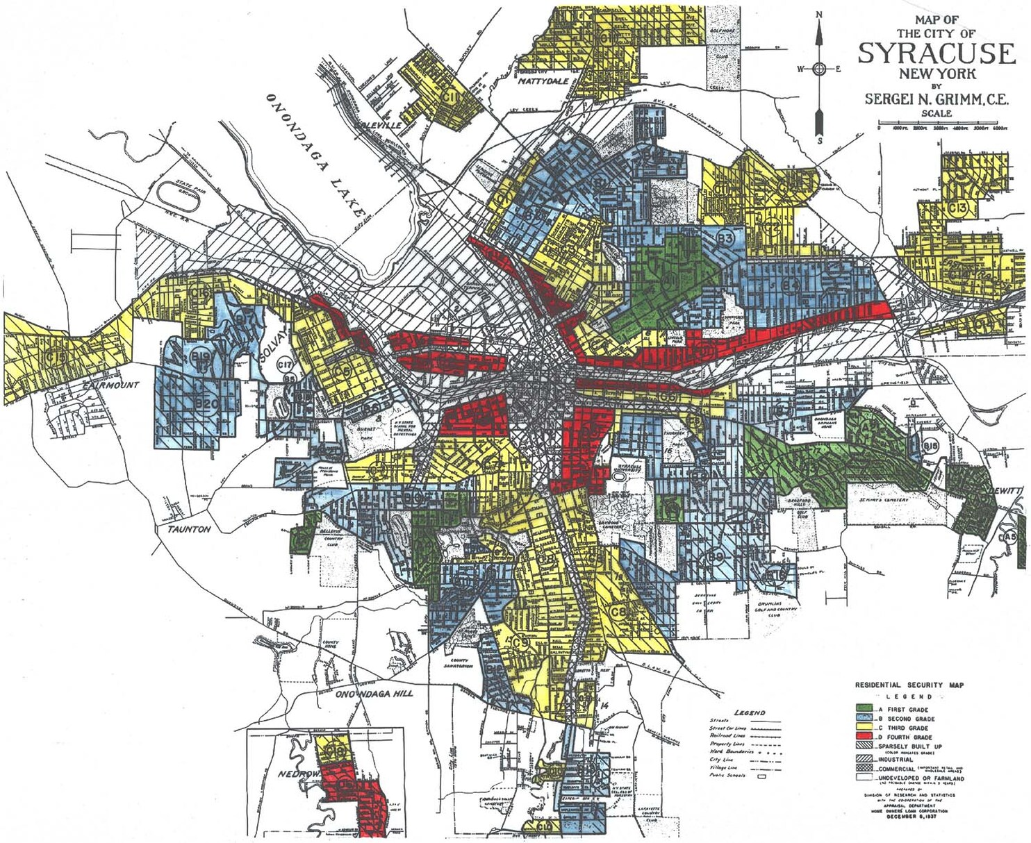
In 1961, banks would not lend to the corridor of red, where I-81 was to be constructed.
The Negative Impact of Rt. 81
The Federal Highway project and the Urban renewal plan uprooted and forced the relocation of more than 1,300 Black families and Jewish owned businesses (Struck 2022). Many of the black families had to move to other under-resourced areas in and around Syracuse. Businesses had to move or close.
One such business was Harrison Bakery. In speaking with the grandson and current owner of Harrison Bakery, Mike Rothfeld in Syracuse, NY, he explained Harrison Bakery was one of seven bakeries on Harrison Street known as “bakers row”. The bakery was frequented by both Black and Jewish residents. Harrison Bakery was forced to relocate to the West Side of Syracuse and they are the only bakery from the 15th Ward’s “bakers row” still in operation.
Removing a barrier to revive a neighborhood
The I-81 construction was completed in 1968. The highway still physically separates some of the poorest and wealthiest communities in the city. The highway infrastructure has deteriorated over the years; it has now become necessary to address what has destroyed a community and added to the segregation in Syracuse for over fifty years.
The Syracuse administration has recently hired an urban planning company from Florida to redesign how Syracuse could be without the highway in the sky that was built to connect cities throughout the country, but divided cities internally like Syracuse in the process (Samuels 2019).
Will city officials be able to correct some of the wrongs from the past by rejuvenating the 15th Ward? Some of the initial plans imagine a vibrant community with an integrated ground level road system without the physical barrier of 1-81. Time will tell, but removing the I-81 infrastructure could be the first move in the right direction both literally and figuratively.
References:
Breidenbach, Michelle. 2022. “$1 Billion Plan for Syracuse Neighborhood near I-81 Revealed: Housing, High School Stadium, Other Surprises.” Syracuse.com October 12 Retrieved March 7, 2024 (https://www.syracuse.com/news/2022/06/1-billion-plan-for-syracuse-neighborhood-near-i-81-revealed-housing-high-school-stadium-other-surprises.html).
Cook, John 2022. “Stakeholder Perspectives of Urban Freeway Removal in Syracuse, NY.Phd Dissertation, Binghamton University”https://www.proquest.com/openview/12fcfa8921e0a18f446415400a3bf7a8/1?cbl=18750&diss=y&pq-origsite=gscholar&parentSessionId=7i1gMKjd8gWM0XE5gfzMxwSsO8oStp0hUGs1flAVOwU%3D
Gruber, Samuel. 2019. “My Central New York.” Blogspot.com. Retrieved March 7, 2024 (https://mycentralnewyork.blogspot.com/2019/10/tracing-syracuses-jewish-buildings-ii.html).
Ished, June. 2023 “Redlining.” Federalreservehistory.org. Retrieved April 22, 2024 (https://www.federalreservehistory.org/essays/redlining).
Jonzella. 2017. “The History of Syracuse’s Jewish Community.” The History of Syracuse’s Jewish Community. Retrieved March 7, 2024 (https://www.cnyhistory.org/2014/12/jewish-community/).
Knight, Aaron C., “Urban Renewal, the 15th Ward, the Empire Stateway and the City of Syracuse, New York” (2007). Syracuse University Honors Program Capstone Projects. 590. https://surface.syr.edu/honors_capstone/590
Mulcahy, Matt. 2021. “The Map: The City Engineer Who Color Coded Syracuse by Ethnicity and Status.” CNY Central Retrieved March 7, 2024 (https://cnycentral.com/news/the-map-segregated-syracuse/the-map-the-city-engineer-who-color-coded-syracuse-by-ethnicity-and-status).
NYCLU. 2021. “The I-81 Story.” New York Civil Liberties Union. Retrieved April 14, 2024 (https://www.nyclu.org/en/campaigns/i-81-story).
Population Census, 1950. Census.gov. Volume 1 New York Retrieved March 7, 2024 (https://www2.census.gov/library/publications/decennial/1950/population-volume-1/vol-01-35.pdf).
Pride, Raquan. “History of the 15th Ward.” Blueprint15.org. Retrieved March 7, 2024 (https://blueprint15.org/history-of-the-15th-ward/).
Renckens, Elizabeth. 2012 “Politics and Planning of the I-81 Corridor in Syracuse, New York.” PhD Dissertation, Department of Sociology, University of Michigan Retrieved April 14, 2024 (https://deepblue.lib.umich.edu/bitstream/handle/2027.42/120394/Renckens_PoliticsAndPlanningOfThe1-81CorridorInSyracuseNewYork.pdf).
Samuels, Robert. 2019. “In Syracuse, a Crumbling Bridge Is Sparking a Conversation About …” In Syracuse, a Road and Reparations. Retrieved March 7, 2024 (https://www.washingtonpost.com/nation/2019/10/20/how-crumbling-bridge-syracuse-is-sparking-conversation-about-reparations/).
Simner, Marvin L. 2006. “Growing up Jewish in the 15th Ward: Recollections from the 1920s through the 1950s” History eBook Collection.7. Retrieved March 7, 2024 (https://ir.lib.uwo.ca/cgi/viewcontent.cgi?article=1007&context=historybooks).
Struck, Jules. 2022. Forced to Live Here, Forced to Leave: The Twin Injustices of I-81 and the Demolition of the 15th Ward. https://www.syracuse.com/news/2022/07/forced-to-live-here-forced-to-leave-the-twin-injustices-of-i-81-and-the-demolition-of-the-15th-ward.html